DTM creation of a quarry from UAV data and comparison with existing models

Für den Entsorgungsbetrieb der Stadt Mainz durften wir ein spannendes Projekt bearbeiten. Im Rahmen des Projekts erhielten wir photogrammetrische Daten des Steinbruchs Mainz Laubenheim. Ziel war die Erstellung eines Digitalen Geländemodells (DGM) aus einer Punktwolke, die die Firma LOGXON GmbH & Co. KG zuvor durch eine Drohnenbefliegung erzeugt hatte. Im Anschluss an die DGM-Erstellung erfolgte der Vergleich der aktuellen DGM-Daten mit dem Modell des Vorjahres und dem Modell des Planungsziels. Wichtig war dabei die Aussage, wie der Auf- und Abtrag im Steinbruch erfolgte und wie der Ist-Bestand verändert werden muss, um das Planungsziel zu erreichen.
Project overview
The waste disposal company of the city of Mainz authorised us to work on an exciting project. Within the scope of the project, we received photogrammetric data of the quarry Mainz Laubenheim. The aim was to create a digital terrain model (DTM) from a point cloud, which the company LOGXON GmbH & Co. KG had previously generated by a drone flight.
Following the creation of the DTM, the current DTM data was compared with the model of the previous year and the model of the planning objective. It was important to know how the cut and fill was carried out in the quarry and how the as-is situation must be changed in order to achieve the planning target.
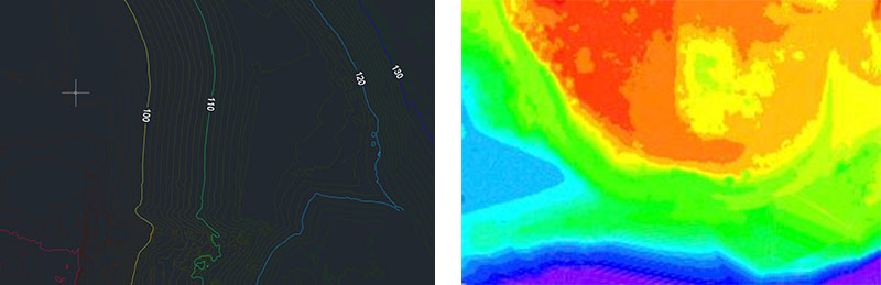
Explanation of terms: A digital terrain model (DTM) maps the real earth surface as a triangulated irregular network (TIN). It refers to the real terrain heights. Excluded from the DTM are heights that are caused by the capture of trees or roofs.
Project schedule
Objective
After consulting with the client and reviewing the data from the previous year, we knew the results expected by the client:
- Triangulation (triangular meshing) in the data formats DWG and PDF
- Contour line map in the data formats DWG and PDF
- Elevation map in the data formats DWG and PDF
- Calculation of cut and fill compared to the model from the previous year
- Calculation of cut and fill compared to the model of the target state
- Creation of profile maps along defined axes and display of the cut and fill information
Acquisition of the 3D data by UAV
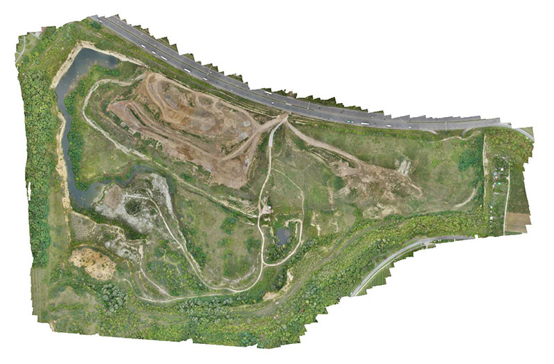
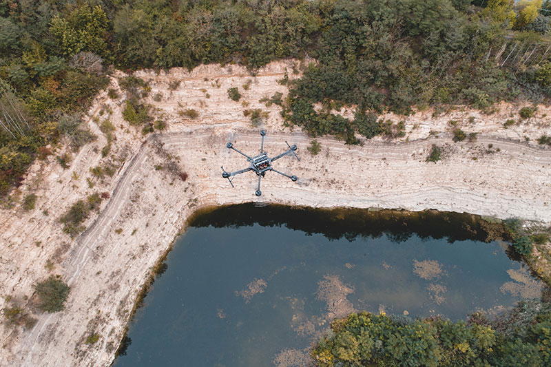
The project area was photogrammetrically surveyed with a special survey drone (LOGXON Porter). Before the UAV flight over the 60 hectares, pass and control points were marked and surveyed with a GPS rover. The pass points were used for geo-referencing and the control points for documenting the provided accuracies.
Subsequently, at a flight altitude of 95m above ground, about 1,300 high-resolution images were taken with a 42-megapixel camera. The ground resolution was 1.15cm. The pre-planned flight over the quarry was semi-automated with the aid of precise GPS control. The pilot took off and landed manually and kept a constant visual contact with the UAV during the autonomous flight.
Photogrammetric analysis
A professional processing of the textured point cloud, based on control points as well as GPS data from the air, was carried out in the Agisoft Metashape Professional software using the measurement images. In addition, very detailed orthophotos with 1.15cm, 5cm and 10m resolution were created on the basis of the point cloud for further processing and visual documentation. The results are handed over with a report on the capture and processing - all relevant parameters and accuracies included.
Project implementation
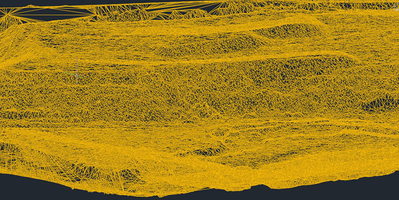
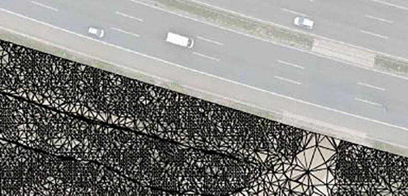
After formatting the output data (LAS file) into the required format and reducing the data to a grid spacing of 5cm, the point cloud was cleaned up in Autodesk ReCap. All objects that do not belong to the terrain (e.g. cars, houses, trees, ...) were deleted or classified.
We then created a model of the quarry from the clean and undisturbed point cloud using Autodesk InfraWorks software. Due to the very steep slopes and the vegetation cover, the model could not be generated completely correctly. We corrected the missing areas by creating break lines.
Explanation of terms: Breaklines are linear objects that are created when the terrain changes, for example at the top of an embankment or at the edge of a road.
The analysis of the model and the comparison with the customer's existing data was done in Autodesk Civil3D.
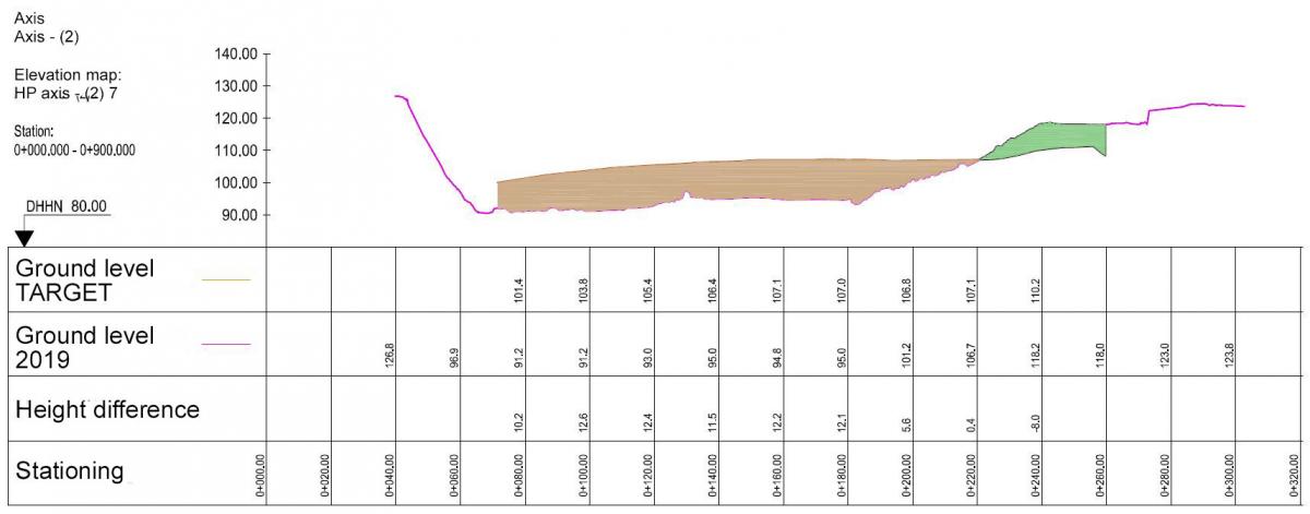
The quantity calculation was used to determine the cut and fill between the models. We were able to pass the result on to our customer both graphically and numerically. Furthermore, we created elevation profile plans along various axes in North South and East West direction. By vectorizing the two axes of the terrain model and specifying the height difference, the cut and fill is even better visible and supports the meaningfulness of the calculation.
The Civil3D software offers many different visualization options in addition to data analysis.
Conclusion
Within the scope of the project, we were able to consolidate and optimize our workflow for DTM creation and DTM comparison. The focus in the creation of digital terrain models from scan data is necessarily on the cleaning of the data and the reasonable thinning (rasterizing) of the point cloud. Particularly in difficult terrain, it is necessary for the operator to check and possibly correct the generated model data. By means of a high-resolution orthophoto the operator is able to view the conditions on site and can assess the automatically generated data very well.
Interested in our services? Simply contact us by phone at +49 (0)391 6269960 or by e-mail to info@laserscanning-europe.com.