Highway Survey with Mobile Mapping for BIM Models of Transport Infrastructure

TitleDigitale Bestandsaufnahme für den Ausbau der A4: BIM-konforme Vermessung und Modellierung
Die A4 zwischen dem Dreieck Nossen und weiter in Fahrtrichtung Bautzen stößt häufig an ihre Kapazitätsgrenzen. Daher stehen Ideen zu einem weiteren Ausbau bzw. Umbau im Raum. Hierfür werden aktuelle Bestandsdaten benötigt. Im Rahmen der Digitalisierung soll eine BIM-konforme Bestandvermessung und Modellierung durchgeführt werden.
Für diese Aufgabenstellung wurde eine Ausschreibung erstellt; die VIC GmbH wurde für ein Teilstück der Autobahn A4 angefragt und beauftragt. Die Verkehrs- und Ingenieurbau Consult GmbH NL Dresden (VIC GmbH) ist als langjähriger Partner der Deutsche Einheit Fernstraßenplanungs- und -bau GmbH (DEGES) mit Planungs- und Vermessungstätigkeiten beauftragt.
TitleProjektanforderungen
Nachfolgende Themenschwerpunkte sind Bestandteil der Ausschreibung:
- Ein BIM-Modell des Autobahnabschnitts als finales Produkt (Grundlage der Ausbauplanung)
- Verwendung von Bestandsdaten
- Erfassung zusätzlicher 3D-Daten, um die Aufgabenstellung BIM-konform zu gewährleisten
- Modellierung der Bauwerke und Streckenbereiche mit unterschiedlichem Level of Detail (LOD)
TitleDurchführung der Vermessung mit verschiedenen Messsystemen
Ausgangslage
In dem betreffenden Autobahnabschnitt befinden sich viele Brückenbauwerke. Die Straßenlage ist bereits durch die Schlussvermessung ausreichend bekannt. Die damals erfassten Brückeninformationen reichen jedoch nicht für eine BIM-konforme Modellierung. Daher ist hier eine zusätzliche Scandatenerfassung erforderlich.
As-built data for highway reconstruction plans
Description of the problem
The German highway A4 between the Nossen highway junction and further in the direction of Bautzen often reaches its capacity limits. Therefore, ideas for a further expansion or reconstruction are under consideration. Current as-built data is needed for this. As part of the digitization process, a BIM-compliant as-built survey and modeling is to be carried out.
A call for tenders was issued for this task; VIC GmbH was requested and commissioned for a section of the A4 highway. The Verkehrs- und Ingenieurbau Consult GmbH NL Dresden (VIC GmbH) is a long-standing partner of the Deutsche Einheit Fernstraßenplanungs- und -bau GmbH (DEGES) and is responsible for planning and surveying activities.
Project requirements
The following key topics are part of the tender:
- A BIM model of the highway section as the final product (basis of the expansion planning).
- Use of as-built data
- Acquisition of additional 3D data to ensure that the task is BIM-compliant
- Modeling of the structures and highway sections with different levels of detail (LOD)
Implementation of the surveying with different measuring systems
Initial situation
There are many bridge structures in the highway section in question. The road position is already sufficiently known from the final survey. However, the bridge information captured at that time is not sufficient for BIM-compliant modeling. Therefore, additional scan data acquisition is required here.
Data acquisition by means of laser scanning
For this purpose, VIC GmbH asked Laserscanning Europe GmbH which scanning methods could best be used to survey the highway and bridges.
Originally, only terrestrial scans were to be used. However, this would have been very costly for the bridge sections in the traffic area of the freeway. Without temporarily closing lanes of the highway, the surveyors would not have been able to work safely. The Laserscanning Europe team thus made the suggestion to additionally use the mobile laser scanning method. From an analysis project carried out earlier – for another federal state – the performance of the procedure and the systems available on the market were already known.
Therefore, the company TopScan GmbH from Rheine was requested as a partner for the project. TopScan GmbH is one of the pioneers in the field of airborne and mobile laser scanning in Germany and has a great wealth of experience.
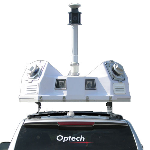
The company uses the Teledyne Optech Lynx Mobile Mapper. The Lynx is a proven high-end mobile mapping system that features great system components, two excellent laser heads and powerful analysis software. However, to take full advantage of these components, it requires some project experience. Of course, the system can be used just "by pushing buttons"; but when high accuracy is required, understanding of the sensors and measurement techniques used is needed. With the right prerequisites, accurate and highly detailed point clouds can be captured at 80 km/h speeds. This allows the measurement vehicle to "float along" with moving traffic and not disrupt the flow of traffic.
Based on the scan data of mobile laser scanning, it is thus already possible to model essential basic structures of bridge structures in a BIM-compliant manner.
Combination of different measuring methods
In order to fulfill the requirements of the tender, a combination of different measurement methods was used. The basic surveying for the survey point field was carried out using GPS, total station and leveling. For the field comparison of the as-built data GPS and tacheometry were used. Terrestrial and mobile laser scanning was used to capture the structures.
Basic surveying is of particular importance in this context. The precise creation of the position and height network forms the basis for the combination of all further measurement methods.
The use of the network points enables the analysis and georeferencing of the terrestrial and mobile mapping data. All data sources are merged into a uniform coordinate system with high accuracy.
Conclusion: Results and outlook
The results of the measurement procedures matched each other right away; only in the case of one structure a marking error had crept into the analysis. This was quickly discovered and the rest of the project could then be quickly processed.
For those involved in the project, the cross-company cooperation was a great challenge. Through excellent communication and coordination, unpopular lane closures were avoided and many days in the field were saved for the surveyor.
The final scan data serves as the basis for modeling the structures in Autodesk Revit. Additional data is included to create the overall model. Existing structure drawings supplement the modeling in "non-visible" areas. Bridge superstructures, foundations, bored piles, etc. can thus be modeled (but not checked).
If mobile laser scanning was used for the entire extension route, modelers could extract a lot of information according to the requirements of the specifications by wisely combining the as-built data with the mapping data. Time-consuming field work (e.g., determining the heights of signs, trees, poles, guidance systems, and noise barriers) associated with costly lane closures could be avoided. However, this is countered by the also time-consuming compaction of the position and height network, the data volumes and calculation times.
Can we also support you with your surveying project? Simply contact us by phone at +49 (0)391 6269960 or by mail at info@laserscanning-europe.com.
TitleFazit: Ergebnisse und Ausblick
Die Ergebnisse der Messverfahren passten auf Anhieb zueinander; nur bei einem Bauwerk hatte sich ein Markierungsfehler in die Auswertung eingeschlichen. Dieser wurde schnell aufgedeckt und im Anschluss konnte das restliche Projekt zügig zusammengerechnet werden.
Für die Projektbeteiligten war die firmenübergreifende Zusammenarbeit eine große Herausforderung. Durch sehr gute Kommunikation und Koordination konnten unbeliebte Sperrungen der Fahrbahn vermieden werden und für den Vermesser wurden viele Tage im Außendienst gespart.
Die finalen Scandaten dienen als Grundlage für die Modellierung der Bauwerke in Autodesk Revit. Für die Erstellung des Gesamtmodells werden zusätzliche Daten eingearbeitet. Vorhandene Bauwerkszeichnungen ergänzen die Modellierung in „nicht sichtbaren“ Bereichen. Brückenaufbauten, Fundamente, Bohrpfähle, etc. können somit modelliert (aber nicht überprüft) werden.
Bei der Verwendung des mobilen Laserscannings für die gesamte Ausbaustrecke könnten die Modellierer durch die kluge Kombination der Bestandsdaten mit den Mapping-Daten viele Informationen entsprechend den Anforderungen der Leistungsbeschreibung entnehmen. Zeitaufwendige Arbeiten im Außendienst (z. B. Bestimmung der Höhen von Schildern, Bäumen, Masten, Leitsystemen und Lärmschutzwänden) verbunden mit kostenintensiven Sperrungen der Fahrbahn könnten vermieden werden. Entgegen stehen dabei aber die ebenfalls zeitaufwendige Verdichtung des Lage- und Höhennetzes, die Datenmengen und Berechnungszeiten.
Können wir auch Sie bei Ihrem Vermessungsprojekt unterstützen?
Kontaktieren Sie uns einfach telefonisch unter +49 (0)391 6269960
oder per Mail an info@laserscanning-europe.com.