GEOVERSE MASSIVE DATA MANAGER 1.3.1 ("MDM") builds on previous offerings by Euclideon. Geoverse MDM enables instant loading of point cloud data (11 LiDAR formats supported) regardless of size. GIS users can centralize Terabytes of LiDAR on a secure server, and access their point clouds over the Internet using a "Drag & Drop" method as simple as DropBox or MediaFire. Massive data management unlocks new doors for organizations that have invested in LiDAR – the point cloud is liberated and accessible from anywhere in the world. Euclideon’s Unlimited Detail 3D Search Engine technology is the only technology that can accomplish this extraordinary feat. The Unlimited Detail algorithm is so efficient that even the largest of point clouds can now stream easily across ordinary ADSL or even mobile 3G.
Major new features in release 1.3.1
Geoverse MDM 1.3.1 offers the user new capabilities that revolutionise the use and application of massive LiDAR data. Users can now:
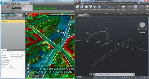
1. APPLY VISUALIZATIONS IN REAL TIME – Colour by height, contour mapping, classification and intensity visualizations are all supported, in real time. No tedious re-processing required! All visualization is performed per pixel, instead of per point. This productivity improvement is a gigantic leap forward for GIS professionals. Create preset visualizations and tie them to bookmarks for outstanding presentations.
2. RECORD DETAILED MEASUREMENTS – Mark up and extract point and line shapes based on your LiDAR data. Layers of measurements can be created with custom line thickness, colours and names. These are saved into Geoverse MDM’s compact UDP project file format and can subsequently be loaded by any user. Since the UDP project file only stores a reference to the streaming point cloud, compact UDP projects containing thousands of shape layers can easily be sent to colleagues or clients.
3. CONNECT TO AUTOCAD® – Use Euclideon’s new Geoverse CAD Connect plugin to mark-up polygonal open and closed shapes in Geoverse MDM and insert these into AutoCAD® drawings in real time. Geoverse CAD Connect eliminates the need for exporting shape files from Geoverse MDM and means that users can leverage their existing investment in their Autodesk design products while taking advantage of centrally stored LiDAR repositories streamed over the Internet. Shapes are as accurate as the LiDAR they are obtained from. Supported AutoCAD® releases: AutoCAD® 2013, 2014 and 2015.
Source: Euclideon Unlimited

